IllinoisAtlas.com


Gis Map Related Links


  Census 2000 U.S. Maps

U.S. Census 2000 Maps featured below are a representative sample of what is available in our inventory. Most are available in sizes ranging from 8½" x 11" to 24" x 36" or 48" x 36". We can also custom design Census maps to your specifications.

 Core-Based Statistical Area Classification
Description: Proposed Core-Based Statistical Area (CBSA) classification system.
Format: Color, 11" x 17", landscape.
JPEG  294 kb
PDF    105 kb
Learn more about the CBSA classification system from the Federal Register documents below:

CBSA 1   787 kb
CBSA 2   268 kb
CBSA 3   299 kb
Order Code: US-C001


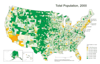
Total Population, 2000
Description: U.S. Total population by county, 2000.
Format: Color, 11" x 17", landscape.
JPEG  250 kb
PDF    304 kb
Data Source: U.S. Census Bureau.
Order Code: US-C002

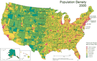
Population Density, 2000
Description: U.S. Population density by county, 2000.
Format: Color, 11" x 17", landscape.
JPEG  308 kb
PDF    303 kb
Data Source: U.S. Census Bureau.
Order Code: US-C003

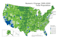
Numeric Change, Total Population 1990-2000
Description: U.S. Population numeric change by county, 1990-2000.
Format: Color, 11" x 17", landscape.
JPEG  234 kb
PDF    303 kb
Data Source: U.S. Census Bureau.
Order Code: US-C004

1    2    3    4    5    Next >


   Illinois
   Basemaps
   Agriculture
   Climate/Environment
   Counties/Metro Areas
   Crime/Public Safety
   Demographic
   Economic
   Education
   Federal Expenditures
   Health/Vital Statistics
   Historical
   Housing/Construction
   Income/Poverty
   Labor Market
   Physical Features
   Political
   Recreational
   Transportation
   United States
   Basemaps
   Agriculture
   Climate/Environment
   Crime/Public Safety
   Demographic
   Economic
   Education
   Federal Expenditures
   Health/Vital Statistics
   Historical
   Housing/Construction
   Income/Poverty
   Labor Market
   Physical Features
   Political
   Recreational
   Transportation
   Utilities
 
    Please report problems to the webmaster.
    Copyright © 2001-2008 by the Regional Development Institute, Northern Illinois University.