 The Center for
Governmental Studies has developed a vast collection of Census related map products.
The maps featured below are a representative sample of what is available in our
inventory. Most are available in sizes ranging from 8½" x 11" to
24" x 36" or 48" x 36". We can also custom design Census maps
to your specifications.
The Center for
Governmental Studies has developed a vast collection of Census related map products.
The maps featured below are a representative sample of what is available in our
inventory. Most are available in sizes ranging from 8½" x 11" to
24" x 36" or 48" x 36". We can also custom design Census maps
to your specifications.
Illinois Census 2000 Sample Map
| Illinois Population by County, Numeric Change 1990-2000. |
| Description: Illionois Resident Population by County-Numeric Change 1990-2000 |
| Format: Color, 8.5" x 11", portrait. |
JPEG 110 kb
PDF 41 kb |
| Data Source: U.S. Census Bureau, Census 2000 |
|
 |
|
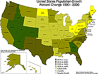
U.S. Census 2000 Sample Map
| U.S. Population Growth 1990-2000 |
| Description: Percent change in total population by state 1990-2000. |
| Format: Color, 8.5" x 11", landscape. |
JPEG 104
kb
PDF 105 kb |
| Data Source: U.S. Census Bureau, Census 2000 |
|
 |
|
|